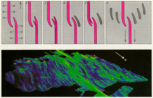
Figure 7. Off-axis features are generated by an overlapping spreading center,
as illustrated in the diagram (top) and the map (bottom). An overlapping
spreading center is depicted (1). A crack develops to the south of the eastern
ridge tip (2), allowing molten rock to surface and form a new ridge tip.
The new tip lengthens until it overlaps the western ridge by three times
the distance that separates them (3). As the regions of rock continue to
pull apart, the original eastern ridge tip breaks off and migrates away
(4). A new western tip begins to form (5). After many episodes of ridge-tip
formation and migration (6), the off-axis structures show a net migration
to the south. The high resolution map of a region near 21°S reveals
an overlapping spreading center that offsets the East Pacific Rise by 12
km. The discontinuity has had a complex evolution during the past 2 million
years. Migration rates have exceeded 200 millimeters per years as northern
and southern ridge tips have surged back and forth, but net migration toward
the south has averaged 20 millimeters per years. Numerous abandoned ridge
tips within a wake of unusually deep sea floor an be seen on both sides
of the overlapping spreading center. Sea-floor structure is disrupted across
an 80 km wide swath adjacent to this discontinuity. Colors indicate depths
of from 2350 (pink) to 2900 (yellow) to 3500 (dark blue).