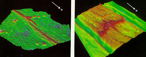
Figure 6. Overlapping spreading center, which cuts across the East Pacific
Rise near 12°N, was surveyed to determine its topography (left) and
magnetization (right). The topographic map shows that the overlapping spreading
center offsets the Rise by 8 km. Colors indicate depths of from 2350 (pink)
to 3500 (dark blue). The two arms of the discontinuity overlap by 27 km.
The arms narrow and deepen near the discontinuity, presumably because the
supply of magma to the region is low. The ocean floor near the discontinuity-also
know as the wake-is unusually deep and is littered with ridge tips, especially
on the west side. It turns out that regions that are not well supplied
with magma are highly magnetized. In the map at the right, magnetization
decreases in strength from red to yellow regions. The map reveals the wake
(red) of the overlapping spreading center. The green-blue troughs were
created 700,000 years ago when the earth's magnetic field reversed polarity.
The wake shows that the overlapping spreading center emerged about 700,000
years ago, migrated north a short distance and then moved slowly south at
70 millimeters per year. In the past 200,000 years migration to the south
has accelerated to 200 millimeters per year.